
Presentanyplaceasaninteractivemap
Turn locations, boundaries, routes, photos, and notes into a shareable interactive map without a heavy GIS workflow.
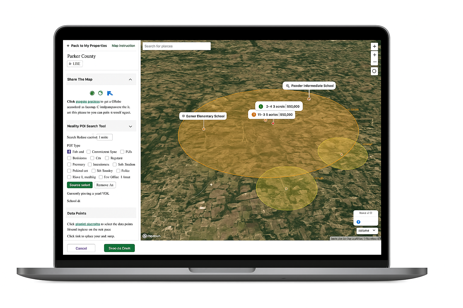
Map properties, sites, and coverage areas
Add photos, notes, routes, and status updates
Share a live map by link, QR, or embed
Collect feedback and field reports on one map
Mapbox
OpenAI
Parcel Data
Reference Layers
OpenStreetMap
Why Teams Use Acre Pixel
Acre Pixel gives teams a clean map layer for explaining where work happens, what matters there, and what changed in the field.
Build a shareable map from any location
Start with an address, coordinate, or place search, then organize boundaries, pins, routes, and nearby context.
Give every place practical context
Clients, crews, and stakeholders can zoom, inspect photos, review status, and understand reference layers in one view.
Collect feedback and field updates
Track views, capture inquiries, and let approved contributors submit photos, descriptions, and custom fields.
Share by link, QR, or one-line embed
Drop it into websites, proposals, emails, or field QR codes. Update the map once instead of resending a PDF.
Built for Location-Based Work
See how location-based teams use Acre Pixel to present sites, service coverage, and field updates
Property Teams
Present parcels, buildings, improvements, access points, and nearby context in one branded interactive map for clients, owners, and internal teams.
Service Operators
Show service areas, territories, routes, stops, and coverage notes so customers and crews understand exactly where work is available.
Field Crews
Turn field observations into map pins with photos, titles, descriptions, and custom fields. Keep updates tied to the exact place they happened.
Consultants & Agencies
Deliver client-ready map presentations for site visits, reports, proposals, and stakeholder reviews without sending a static PDF.
How It Works
Three simple steps to create, share, and update your interactive map presentation.
Choose a Location
Start from an address, coordinate, or place search to frame a property, service area, or field site.
Add Map Context
Add boundaries, routes, photos, status, notes, and custom fields to create a complete interactive presentation.
Share & Update
Publish by link, QR code, or embed, then track views and keep collecting feedback or field reports.
Everything a Map Presentation Needs — Built In
🤖 Start from an address, coordinate, or place search, then draft boundaries, points, and useful nearby context.
📍 Mark properties, service areas, access routes, assets, hazards, repairs, inspections, and follow-up items.
🧭 Layer satellite, topo, parcel, and nearby reference data so every location has practical context.
🔗 Share by link, QR, or embed. Track views, capture inquiries, and keep each map presentation current.
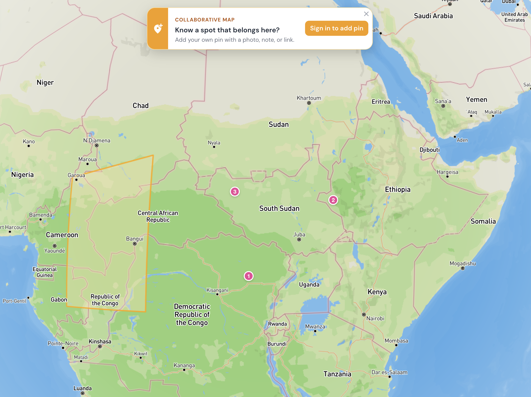
One map, everyone contributes
Turn on collaboration and approved visitors can drop pins on your map — with photos, titles, descriptions, and the custom fields you define. Compare submissions side-by-side so teams, clients, or communities can decide together.
Contributors can edit or delete their own pins
Custom fields you define — status, link, contact info, validated on submit
Compare up to 4 pins side-by-side
Owners can hide or remove unsuitable submissions
Built for Maps People Actually Use
Most map tools are either too static or too complex. Acre Pixel sits between them: a lightweight presentation layer for properties, service areas, and field reports that makes location-based work understandable to clients, crews, and stakeholders.

Try Acre Pixel Free
10 free presentations to start. No credit card. Upgrade anytime for unlimited maps, branded embeds, collaboration, and priority support.
Starter
Small teams mapping their first sitesFree
Everything you need to publish your first 10 map presentations.
✔ Up to 10 published presentations
✔ Boundaries, pins, routes & context
✔ Upload photos & media
✔ Share via link or QR code
✔ Basic view analytics
Pro Monthly
Teams sharing maps every week$9.9/mo
Unlimited map presentations, branding, and priority support.
✔ Unlimited presentations
✔ Everything in Starter
✔ Priority support
✔ Custom branding & embed widget
✔ Collaboration & inquiry capture
Pro Annual
Operations, agencies & power users$99/yr
Save 17% — two months free with annual billing.
✔ Unlimited presentations
✔ Everything in Pro Monthly
✔ Priority support
✔ Custom branding & embed widget
✔ Early access to new map and report layers
Free for up to 10 presentations. No credit card required.
Questions teams ask us
No. Acre Pixel is built for presentation, not heavyweight GIS administration. Start with a location, add the layers and notes you need, then share.
Yes. Every published map includes a link, QR code, and one-line embed snippet that works on Squarespace, Wix, WordPress, or a custom site.
Satellite and topo are available today. Parcel and additional reference layers are being expanded so teams can show property, service, and field context in one place.
GIS platforms are built for deep analysis, and PDFs go stale immediately. Acre Pixel is a lightweight presentation layer: branded, interactive, shareable, and easy to update.
Yes. Collaboration mode lets approved visitors add pins with photos, descriptions, and custom fields. Owners can review, hide, or remove submissions.
Yes — no contracts. Cancel in one click and keep access to your 10 free presentations.
Contact Us
We'd love to hear from you. Fill out the form below, or send us an email directly.
Acre Pixel
A lightweight interactive map presentation layer for properties, service areas, and field reports.
Get Started
Free for up to 10 presentations. No credit card required.
© 2026 Acre Pixel. All rights reserved.